


chaligny_13km

ZAMBAUX
User
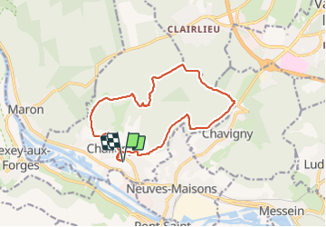

Length
13.7 km

Max alt
405 m

Uphill gradient
328 m
Km-Effort
18.1 km

Min alt
246 m

Downhill gradient
327 m
Boucle
Yes
Creation date :
2022-01-27 12:43:38.492
Updated on :
2022-01-27 16:00:08.522
3h15
Difficulty : Difficult

FREE GPS app for hiking
 SityTrail
IGN / Geographical institutes
SityTrail Plus
The world is yours!
About
Trail Walking of 13.7 km to be discovered at Grand Est, Meurthe-et-Moselle, Chaligny. This trail is proposed by ZAMBAUX.
Positioning
Country:
France
Region :
Grand Est
Department/Province :
Meurthe-et-Moselle
Municipality :
Chaligny
Location:
Unknown
Start:(Dec)
Start:(UTM)
285226 ; 5389577 (32U) N.
Comments