


Grospierre Chastelas 14km

thonyc
User GUIDE
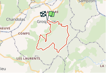

Length
14.1 km

Max alt
479 m

Uphill gradient
499 m
Km-Effort
21 km

Min alt
129 m

Downhill gradient
502 m
Boucle
Yes
Creation date :
2022-01-28 13:53:43.309
Updated on :
2022-01-28 14:02:46.742
4h43
Difficulty : Medium

FREE GPS app for hiking
 SityTrail
IGN / Geographical institutes
SityTrail Plus
The world is yours!
About
Trail Walking of 14.1 km to be discovered at Auvergne-Rhône-Alpes, Ardèche, Grospierres. This trail is proposed by thonyc.
Positioning
Country:
France
Region :
Auvergne-Rhône-Alpes
Department/Province :
Ardèche
Municipality :
Grospierres
Location:
Unknown
Start:(Dec)
Start:(UTM)
602715 ; 4917216 (31T) N.
Comments