Volcan Chirouse 15km

thonyc
User GUIDE

Length
14.3 km

Max alt
729 m

Uphill gradient
648 m
Km-Effort
23 km

Min alt
340 m

Downhill gradient
648 m
Boucle
Yes
Creation date :
2022-01-28 14:16:26.776
Updated on :
2022-01-28 14:20:04.16
5h12
Difficulty : Difficult

FREE GPS app for hiking
 SityTrail
IGN / Geographical institutes
SityTrail Plus
The world is yours!
About
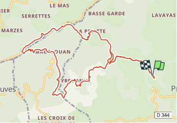
Trail Walking of 14.3 km to be discovered at Auvergne-Rhône-Alpes, Ardèche, Pranles. This trail is proposed by thonyc.
Positioning
Country:
France
Region :
Auvergne-Rhône-Alpes
Department/Province :
Ardèche
Municipality :
Pranles
Location:
Unknown
Start:(Dec)
Start:(UTM)
623715 ; 4959150 (31T) N.
Comments