


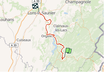
jura du haut en bas. 70km

phil21
User

Length
72 km

Max alt
918 m

Uphill gradient
1451 m
Km-Effort
93 km

Min alt
244 m

Downhill gradient
1747 m
Boucle
No
Creation date :
2014-12-10 00:00:00.0
Updated on :
2014-12-10 00:00:00.0
5h18
Difficulty : Difficult

FREE GPS app for hiking
 SityTrail
IGN / Geographical institutes
SityTrail Plus
The world is yours!
About
Trail Mountain bike of 72 km to be discovered at Bourgogne-Franche-Comté, Jura, Lavans-lès-Saint-Claude. This trail is proposed by phil21.
Positioning
Country:
France
Region :
Bourgogne-Franche-Comté
Department/Province :
Jura
Municipality :
Lavans-lès-Saint-Claude
Location:
Lavans-lès-Saint-Claude
Start:(Dec)
Start:(UTM)
713597 ; 5140184 (31T) N.
Comments