


2021 08 BAGNOLS T5

michel1025
User
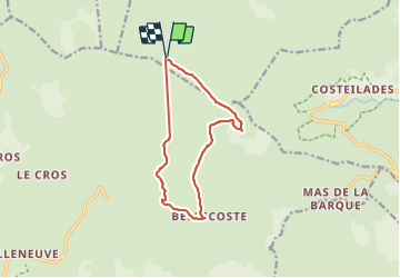

Length
11.8 km

Max alt
1678 m

Uphill gradient
363 m
Km-Effort
16.7 km

Min alt
1360 m

Downhill gradient
362 m
Boucle
Yes
Creation date :
2021-08-13 07:59:04.0
Updated on :
2022-01-30 15:41:41.759
3h52
Difficulty : Difficult

FREE GPS app for hiking
 SityTrail
IGN / Geographical institutes
SityTrail Plus
The world is yours!
About
Trail Walking of 11.8 km to be discovered at Occitania, Lozère, Altier. This trail is proposed by michel1025.
Positioning
Country:
France
Region :
Occitania
Department/Province :
Lozère
Municipality :
Altier
Location:
Unknown
Start:(Dec)
Start:(UTM)
565512 ; 4918524 (31T) N.
Comments