


Autour de Miribel - 30 janvier 2022

morganee
User
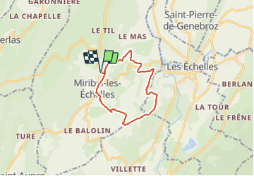

Length
10.5 km

Max alt
608 m

Uphill gradient
356 m
Km-Effort
15.3 km

Min alt
399 m

Downhill gradient
357 m
Boucle
Yes
Creation date :
2022-01-30 13:10:31.743
Updated on :
2022-01-30 16:00:11.969
2h49
Difficulty : Easy

FREE GPS app for hiking
 SityTrail
IGN / Geographical institutes
SityTrail Plus
The world is yours!
About
Trail Walking of 10.5 km to be discovered at Auvergne-Rhône-Alpes, Isère, Miribel-les-Échelles. This trail is proposed by morganee.
Positioning
Country:
France
Region :
Auvergne-Rhône-Alpes
Department/Province :
Isère
Municipality :
Miribel-les-Échelles
Location:
Unknown
Start:(Dec)
Start:(UTM)
711994 ; 5034708 (31T) N.
Comments