


Frank

Swakke
User

Length
14.1 km

Max alt
111 m

Uphill gradient
119 m
Km-Effort
15.7 km

Min alt
52 m

Downhill gradient
120 m
Boucle
Yes
Creation date :
2022-01-30 13:26:54.898
Updated on :
2022-01-30 16:56:12.654
3h28
Difficulty : Easy

FREE GPS app for hiking
 SityTrail
IGN / Geographical institutes
SityTrail Plus
The world is yours!
About
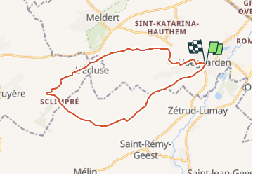
Trail Walking of 14.1 km to be discovered at Flanders, Flemish Brabant, Hoegaarden. This trail is proposed by Swakke.
Description
Hoegaarden - L'écluse 14 km
Positioning
Country:
Belgium
Region :
Flanders
Department/Province :
Flemish Brabant
Municipality :
Hoegaarden
Location:
Hoegaarden
Start:(Dec)
Start:(UTM)
633106 ; 5626345 (31U) N.
Comments