


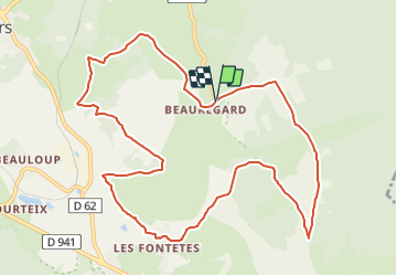
Beauregard Fontéte

jeanic63
User

Length
12 km

Max alt
987 m

Uphill gradient
212 m
Km-Effort
14.9 km

Min alt
826 m

Downhill gradient
220 m
Boucle
Yes
Creation date :
2022-01-31 14:53:14.286
Updated on :
2022-01-31 15:23:43.601
3h28
Difficulty : Easy

FREE GPS app for hiking
 SityTrail
IGN / Geographical institutes
SityTrail Plus
The world is yours!
About
Trail On foot of 12 km to be discovered at Auvergne-Rhône-Alpes, Puy-de-Dôme, Saint-Ours. This trail is proposed by jeanic63.
Description
départ Beauregard parking village
Positioning
Country:
France
Region :
Auvergne-Rhône-Alpes
Department/Province :
Puy-de-Dôme
Municipality :
Saint-Ours
Location:
Unknown
Start:(Dec)
Start:(UTM)
494575 ; 5076466 (31T) N.
Comments