


Tutorat BM Yerres - Brunoy - Montgeron -12 km

jeanmarcMasson
User GUIDE
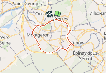

Length
12.1 km

Max alt
95 m

Uphill gradient
94 m
Km-Effort
13.4 km

Min alt
31 m

Downhill gradient
94 m
Boucle
Yes
Creation date :
2022-02-01 13:40:57.668
Updated on :
2022-02-01 13:42:23.116
3h02
Difficulty : Difficult

FREE GPS app for hiking
 SityTrail
IGN / Geographical institutes
SityTrail Plus
The world is yours!
About
Trail Walking of 12.1 km to be discovered at Ile-de-France, Essonne, Yerres. This trail is proposed by jeanmarcMasson.
Positioning
Country:
France
Region :
Ile-de-France
Department/Province :
Essonne
Municipality :
Yerres
Location:
Unknown
Start:(Dec)
Start:(UTM)
461657 ; 5395930 (31U) N.
Comments