


St Leu -Domont

Bernardcom
User
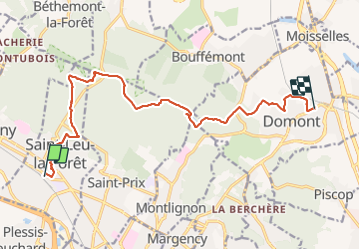

Length
13.4 km

Max alt
189 m

Uphill gradient
245 m
Km-Effort
16.6 km

Min alt
77 m

Downhill gradient
222 m
Boucle
No
Creation date :
2022-02-01 09:28:38.226
Updated on :
2022-02-01 14:39:27.314
5h09
Difficulty : Very easy

FREE GPS app for hiking
 SityTrail
IGN / Geographical institutes
SityTrail Plus
The world is yours!
About
Trail Walking of 13.4 km to be discovered at Ile-de-France, Val-d'Oise, Saint-Leu-la-Forêt. This trail is proposed by Bernardcom.
Positioning
Country:
France
Region :
Ile-de-France
Department/Province :
Val-d'Oise
Municipality :
Saint-Leu-la-Forêt
Location:
Unknown
Start:(Dec)
Start:(UTM)
444646 ; 5429510 (31U) N.
Comments