


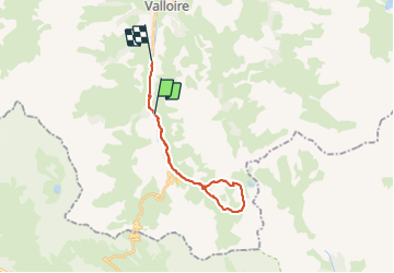
col des Cerces

CABERMAT
User

Length
20 km

Max alt
2583 m

Uphill gradient
897 m
Km-Effort
33 km

Min alt
1578 m

Downhill gradient
1046 m
Boucle
No
Creation date :
2022-02-01 08:48:28.931
Updated on :
2022-02-01 15:08:29.335
6h18
Difficulty : Very easy

FREE GPS app for hiking
 SityTrail
IGN / Geographical institutes
SityTrail Plus
The world is yours!
About
Trail Touring skiing of 20 km to be discovered at Auvergne-Rhône-Alpes, Savoy, Valloire. This trail is proposed by CABERMAT.
Positioning
Country:
France
Region :
Auvergne-Rhône-Alpes
Department/Province :
Savoy
Municipality :
Valloire
Location:
Unknown
Start:(Dec)
Start:(UTM)
297156 ; 4999141 (32T) N.
Comments