


rando tuto BM 21km

jeanmarcMasson
User GUIDE
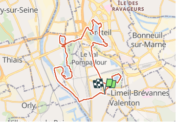

Length
21 km

Max alt
55 m

Uphill gradient
164 m
Km-Effort
24 km

Min alt
25 m

Downhill gradient
165 m
Boucle
Yes
Creation date :
2022-02-02 08:22:52.917
Updated on :
2022-02-02 16:11:46.803
6h38
Difficulty : Very difficult

FREE GPS app for hiking
 SityTrail
IGN / Geographical institutes
SityTrail Plus
The world is yours!
About
Trail Walking of 21 km to be discovered at Ile-de-France, Val-de-Marne, Villeneuve-Saint-Georges. This trail is proposed by jeanmarcMasson.
Positioning
Country:
France
Region :
Ile-de-France
Department/Province :
Val-de-Marne
Municipality :
Villeneuve-Saint-Georges
Location:
Unknown
Start:(Dec)
Start:(UTM)
460000 ; 5399631 (31U) N.
Comments