


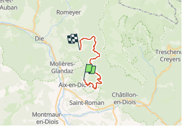
Laval d Aix

raygautier
User

Length
18 km

Max alt
1084 m

Uphill gradient
1037 m
Km-Effort
32 km

Min alt
551 m

Downhill gradient
985 m
Boucle
No
Creation date :
2022-02-03 08:11:26.0
Updated on :
2022-02-03 14:52:47.12
6h40
Difficulty : Unknown

FREE GPS app for hiking
 SityTrail
IGN / Geographical institutes
SityTrail Plus
The world is yours!
About
Trail Walking of 18 km to be discovered at Auvergne-Rhône-Alpes, Drôme, Laval-d'Aix. This trail is proposed by raygautier.
Positioning
Country:
France
Region :
Auvergne-Rhône-Alpes
Department/Province :
Drôme
Municipality :
Laval-d'Aix
Location:
Unknown
Start:(Dec)
Start:(UTM)
692397 ; 4953849 (31T) N.
Comments