Trail Walking Saint-Privat - 
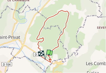
ST Privat-Mont Champ - Photo
 Linerou
Linerou

User

© OpenStreetMap contributors
Length
Length
7.6 km
Max alt
Max alt
502 m
Uphill gradient
Uphill gradient
314 m
Km-Effort
Km-Effort  
11.8 km
Min alt
Min alt
191 m
Downhill gradient
Downhill gradient
318 m
Boucle
Boucle
Yes
Creation date :
2022-02-05 09:22:52.777
Updated on :
2022-02-05 09:23:30.489

(0 Reviews)

Walking
Walking
2h40
Difficulty : Medium

Scan this QR Code to open this trail in the SityTrail application

FREE GPS app for hiking

Logo SityTrail SityTrail

IGN / Geographical institutes

Download SityTrail from the App Store Download SityTrail from Google Play

Logo SityTrail SityTrail Plus

The world is yours!

Download SityTrail from the App Store Download SityTrail from Google Play Download SityTrail on Huawei AppGallery

About

Trail Walking of 7.6 km to be discovered at Auvergne-Rhône-Alpes, Ardèche, Saint-Privat. This trail is proposed by Linerou.

Elevation profile

Points of interest

Point of interest Saint-Privat - D259, parking devant le camping - Photo
Linerou
Point of interest Saint-Privat - Chemin à gauche avant le pont - Photo
Linerou
Point of interest Saint-Privat - Croisement, continuer tout droit - Photo
Linerou
Point of interest Saint-Privat - Tout droit, descente raide - Photo
Linerou
Point of interest Saint-Privat - Traverser le ruisseau - Photo
Linerou
SAINT-PRIVAT 
Point of interest Saint-Privat - A gauche, traverser le ruisseau - Photo
Linerou
Point of interest Saint-Privat - A gauche en arrière - Photo
Linerou
SAINT-PRIVAT 
Point of interest Saint-Privat - Route à gauche - Photo
Linerou
SAINT-PRIVAT 
Point of interest Saint-Privat - D259, parking devant le camping - Photo
Linerou

Positioning

Country:
France
Region :
Auvergne-Rhône-Alpes
Department/Province :
Ardèche
Municipality :
Saint-Privat
Location:
Unknown
Start:(UTM)
613620 ; 4941725 (31T) N.


Close
My subscriptions