


Aurel_18km-5899391-1644066077-507

thonyc
User GUIDE
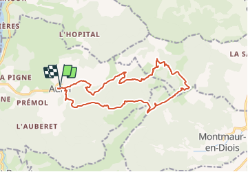

Length
17.4 km

Max alt
1249 m

Uphill gradient
887 m
Km-Effort
29 km

Min alt
410 m

Downhill gradient
892 m
Boucle
Yes
Creation date :
2022-02-05 13:02:27.116
Updated on :
2022-02-05 13:44:27.496
5h00
Difficulty : Medium

FREE GPS app for hiking
 SityTrail
IGN / Geographical institutes
SityTrail Plus
The world is yours!
About
Trail Walking of 17.4 km to be discovered at Auvergne-Rhône-Alpes, Drôme, Aurel. This trail is proposed by thonyc.
Positioning
Country:
France
Region :
Auvergne-Rhône-Alpes
Department/Province :
Drôme
Municipality :
Aurel
Location:
Unknown
Start:(Dec)
Start:(UTM)
682154 ; 4951677 (31T) N.
Comments