


Chaud Clapier

thonyc
User GUIDE
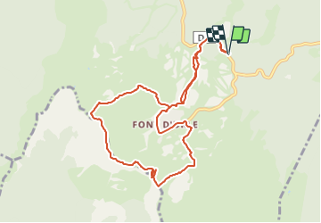

Length
10.4 km

Max alt
1659 m

Uphill gradient
393 m
Km-Effort
15.6 km

Min alt
1386 m

Downhill gradient
393 m
Boucle
Yes
Creation date :
2022-02-05 13:22:23.153
Updated on :
2022-02-05 13:23:41.229
3h33
Difficulty : Medium
4h10
Difficulty : Medium

FREE GPS app for hiking
 SityTrail
IGN / Geographical institutes
SityTrail Plus
The world is yours!
About
Trail Walking of 10.4 km to be discovered at Auvergne-Rhône-Alpes, Drôme, Bouvante. This trail is proposed by thonyc.
Positioning
Country:
France
Region :
Auvergne-Rhône-Alpes
Department/Province :
Drôme
Municipality :
Bouvante
Location:
Unknown
Start:(Dec)
Start:(UTM)
684256 ; 4975431 (31T) N.
Comments