


rando Philippe haybes

Tommy Eric
User
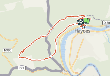

Length
11.1 km

Max alt
378 m

Uphill gradient
351 m
Km-Effort
15.8 km

Min alt
111 m

Downhill gradient
352 m
Boucle
Yes
Creation date :
2022-02-05 12:34:03.775
Updated on :
2022-02-05 16:49:47.101
4h15
Difficulty : Difficult

FREE GPS app for hiking
 SityTrail
IGN / Geographical institutes
SityTrail Plus
The world is yours!
About
Trail Walking of 11.1 km to be discovered at Grand Est, Ardennes, Haybes. This trail is proposed by Tommy Eric.
Positioning
Country:
France
Region :
Grand Est
Department/Province :
Ardennes
Municipality :
Haybes
Location:
Unknown
Start:(Dec)
Start:(UTM)
622192 ; 5541290 (31U) N.
Comments