


tour du repy

sterdyniak
User
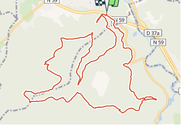

Length
16.9 km

Max alt
596 m

Uphill gradient
641 m
Km-Effort
25 km

Min alt
319 m

Downhill gradient
646 m
Boucle
Yes
Creation date :
2022-02-06 08:51:41.949
Updated on :
2022-02-06 11:30:19.13
2h37
Difficulty : Very easy

FREE GPS app for hiking
 SityTrail
IGN / Geographical institutes
SityTrail Plus
The world is yours!
About
Trail Trail of 16.9 km to be discovered at Grand Est, Vosges, Raon-l'Étape. This trail is proposed by sterdyniak.
Description
Pierre d'appel
Positioning
Country:
France
Region :
Grand Est
Department/Province :
Vosges
Municipality :
Raon-l'Étape
Location:
Unknown
Start:(Dec)
Start:(UTM)
340571 ; 5362588 (32U) N.
Comments