


levens le ferion

pln30
User
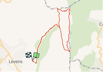

Length
11.4 km

Max alt
1399 m

Uphill gradient
740 m
Km-Effort
21 km

Min alt
663 m

Downhill gradient
737 m
Boucle
Yes
Creation date :
2022-02-06 08:12:34.736
Updated on :
2022-03-12 11:23:54.423
5h19
Difficulty : Medium

FREE GPS app for hiking
 SityTrail
IGN / Geographical institutes
SityTrail Plus
The world is yours!
About
Trail Walking of 11.4 km to be discovered at Provence-Alpes-Côte d'Azur, Maritime Alps, Levens. This trail is proposed by pln30.
Description
rando menant de levens (madone) à la tour de guet du ferion
pour un apercu de la rando et du lieu regardez ma video youtube
sur la chaine Air View Channel
Positioning
Country:
France
Region :
Provence-Alpes-Côte d'Azur
Department/Province :
Maritime Alps
Municipality :
Levens
Location:
Unknown
Start:(Dec)
Start:(UTM)
359362 ; 4856440 (32T) N.
Comments