


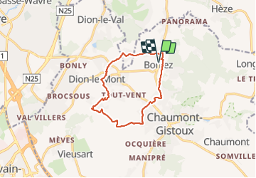
Dion-le-mont
© OpenStreetMap contributors


3h46
Difficulty : Difficult


Length
11.1 km
Max alt
129 m
Uphill gradient
180 m
Km-Effort
13.5 km
Min alt
68 m
Downhill gradient
180 m
Boucle
Yes
Creation date :
2022-01-30 08:54:27.0
Updated on :
2022-02-06 20:13:23.317
3h46
Difficulty : Difficult
FREE GPS app for hiking
 SityTrail
IGN / Geographical institutes
SityTrail Plus
The world is yours!
About
Trail Walking of 11.1 km to be discovered at Wallonia, Walloon Brabant, Chaumont-Gistoux. This trail is proposed by 001433.7bed7ed0214a4463aa3b337c51a300eb.1151.
Positioning
Country:
Belgium
Region :
Wallonia
Department/Province :
Walloon Brabant
Municipality :
Chaumont-Gistoux
Location:
Unknown
Start:(Dec)
Start:(UTM)
619313 ; 5618121 (31U) N.
Comments