Trail Walking Jalhay - Chemin des Sources |stage 5 SOLWASTER - JALHAY - Photo

Chemin des Sources |stage 5 SOLWASTER - JALHAY

Découvrez votre nature PRO

© OpenStreetMap contributors
Length
Length
17.1 km
Max alt
Max alt
632 m
Uphill gradient
Uphill gradient
336 m
Km-Effort
Km-Effort  
22 km
Min alt
Min alt
363 m
Downhill gradient
Downhill gradient
320 m
Boucle
Boucle
No
Creation date :
2022-02-08 13:44:29.291
Updated on :
2024-01-12 15:02:54.277

(2 Reviews)

Walking
Walking
4h53
Difficulty : Very difficult

Scan this QR Code to open this trail in the SityTrail application

FREE GPS app for hiking

Logo SityTrail SityTrail

IGN / Geographical institutes

Download SityTrail from the App Store Download SityTrail from Google Play

Logo SityTrail SityTrail World

The world is yours!

Download SityTrail from the App Store Download SityTrail from Google Play Download SityTrail on Huawei AppGallery

About

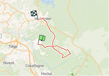
Trail Walking of 17.1 km to be discovered at Wallonia, Liège, Jalhay. This trail is proposed by Chemin des Sources.

Description

From the start, a path takes you into the Statte valley where you will discover a world of legends such as the boulder of Bilisse, the scree and the waterfall of the Nutons.

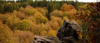
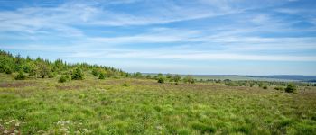
The Hautes Fagnes must be earned and it is after a long climb that the Chemin des Sources reaches the heart of its wonderful Nature Reserve.
This exceptional site is a protected area where the rules are strictly applied.

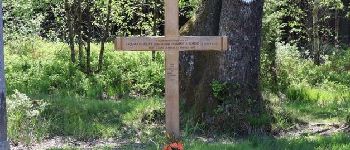
The Fiancees Cross , on the Vecquée, is the highest point (640 m) of the 9 stages.

After a pleasant walk through deciduous woods, you will arrive at the village of Jalhay, the land of green cabbage.

Elevation profile

Photos

Points of interest

Point of interest Jalhay - v - Photo
Chemin des Sources
JALHAY 
Point of interest Jalhay - Cross of the Fiancés - Photo
Chemin des Sources
Point of interest Waimes - The High Fens - Photo
Chemin des Sources
Point of interest Jalhay - FINISH - Photo
Supersylvain
JALHAY 

Positioning

Country:
Belgium
Region :
Wallonia
Department/Province :
Liège
Municipality :
Jalhay
Location:
Unknown
Start:(Dec)
Start:(UTM)
710295 ; 5601067 (31U) N.

Comments

Please log in to post a review or rate the element


Splendide première partie le long de la Statte jusqu'au Hautes Fagnes, tandis que le retour est plus monotone avec de longues lignes droites.


Trails nearby

Trail Walking Jalhay - RB-LG-06 Raccourci 2 - Photo
Walking
PRO

Walking

Difficult
(6)
Jalhay, Wallonia, Liège, Belgium
14.1 km | 18.7 km-effort
4h 14min
Yes
Trail Walking Jalhay - RB-LG-06 - Au pied du plateau des Hautes Fagnes La balade des ruisseaux - Photo
Walking
PRO

Walking

Very difficult
(7)
Jalhay, Wallonia, Liège, Belgium
27 km | 36 km-effort
8h 11min
Yes
Trail Walking Jalhay - Solwaster. Natura 2000, des sites qui valent le détour. Lg8 - Photo
Walking
GUIDE+

Walking

Difficult
(9)
Jalhay, Wallonia, Liège, Belgium
6.8 km | 9.1 km-effort
1h 58min
Yes
Trail Walking Jalhay - Pont de Belleheid à Spa par le GRP 573 - Photo
Walking
GUIDE
mumu.larandonneuse

Walking

Medium
(1)
Jalhay, Wallonia, Liège, Belgium
14 km | 17.8 km-effort
4h 2min
No
Trail Walking Theux - 20220901 - Jehanster 5.3 Km - Photo
Walking
GUIDE
pierreh01

Walking

Medium
(1)
Theux, Wallonia, Liège, Belgium
5.3 km | 6.8 km-effort
1h 32min
Yes
Trail Walking Stavelot - 20211213 - Hockay 5.4 Km - Photo
Walking
GUIDE
pierreh01

Walking

Medium
(3)
Stavelot, Wallonia, Liège, Belgium
5.1 km | 6.6 km-effort
1h 34min
Yes
Trail Walking Jalhay - 2021-11-16_21h27m43_Cirkwi-Balade_à_Jalhay-Royompré_-_47 - Photo
Walking
GUIDE
mumu.larandonneuse

Walking

Easy
(2)
Jalhay, Wallonia, Liège, Belgium
11 km | 13.9 km-effort
3h 9min
Yes
Trail Walking Jalhay - 2021-11-16_21h12m11_Cirkwi-Solwaster_Sawe_-_balade_56_B (1) - Photo
Walking
GUIDE
mumu.larandonneuse

Walking

Medium
(2)
Jalhay, Wallonia, Liège, Belgium
8.5 km | 11.4 km-effort
2h 36min
Yes
Trail Running Jalhay - Jalhay-Trail-26km - Photo
Running
florkin

Running

Difficult
(9)
Jalhay, Wallonia, Liège, Belgium
26 km | 34 km-effort
3h 0min
Yes


Close
My subscriptions