


villeperdrix

losjo
User
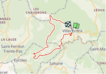

Length
16.5 km

Max alt
928 m

Uphill gradient
796 m
Km-Effort
27 km

Min alt
426 m

Downhill gradient
771 m
Boucle
Yes
Creation date :
2022-02-08 08:17:56.297
Updated on :
2022-02-08 16:00:46.448
7h41
Difficulty : Very difficult

FREE GPS app for hiking
 SityTrail
IGN / Geographical institutes
SityTrail Plus
The world is yours!
About
Trail Walking of 16.5 km to be discovered at Auvergne-Rhône-Alpes, Drôme, Villeperdrix. This trail is proposed by losjo.
Description
rando
Positioning
Country:
France
Region :
Auvergne-Rhône-Alpes
Department/Province :
Drôme
Municipality :
Villeperdrix
Location:
Unknown
Start:(Dec)
Start:(UTM)
681962 ; 4923331 (31T) N.
Comments