


Marron La Sarrasine

topnature !
User

Length
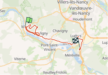
25 km

Max alt
382 m

Uphill gradient
390 m
Km-Effort
30 km

Min alt
210 m

Downhill gradient
369 m
Boucle
No
Creation date :
2022-02-08 12:49:39.0
Updated on :
2022-02-08 16:45:19.598
3h53
Difficulty : Very difficult

FREE GPS app for hiking
 SityTrail
IGN / Geographical institutes
SityTrail Plus
The world is yours!
About
Trail Walking of 25 km to be discovered at Grand Est, Meurthe-et-Moselle, Maron. This trail is proposed by topnature !.
Description
Forêt
Positioning
Country:
France
Region :
Grand Est
Department/Province :
Meurthe-et-Moselle
Municipality :
Maron
Location:
Unknown
Start:(Dec)
Start:(UTM)
282287 ; 5391109 (32U) N.
Comments