


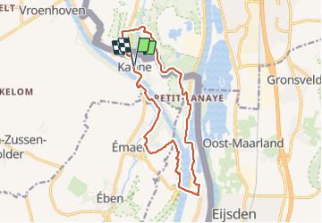
Canne, Eben-Emael, Montagne Saint-Pierre

Philippe Moraux
User

Length
14 km

Max alt
126 m

Uphill gradient
240 m
Km-Effort
17.2 km

Min alt
46 m

Downhill gradient
239 m
Boucle
Yes
Creation date :
2022-02-10 12:35:43.087
Updated on :
2022-02-10 15:37:45.388
3h01
Difficulty : Medium

FREE GPS app for hiking
 SityTrail
IGN / Geographical institutes
SityTrail Plus
The world is yours!
About
Trail Walking of 14 km to be discovered at Flanders, Limburg, Riemst. This trail is proposed by Philippe Moraux.
Positioning
Country:
Belgium
Region :
Flanders
Department/Province :
Limburg
Municipality :
Riemst
Location:
Kanne
Start:(Dec)
Start:(UTM)
688053 ; 5632557 (31U) N.
Comments