


2022-02-11_07h32m03_Rando Aspires Fraissines

tercla
User
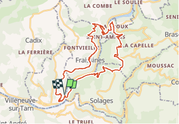

Length
23 km

Max alt
538 m

Uphill gradient
759 m
Km-Effort
33 km

Min alt
212 m

Downhill gradient
754 m
Boucle
Yes
Creation date :
2022-02-11 06:32:07.53
Updated on :
2025-03-13 15:59:55.079
7h25
Difficulty : Difficult

FREE GPS app for hiking
 SityTrail
IGN / Geographical institutes
SityTrail Plus
The world is yours!
About
Trail On foot of 23 km to be discovered at Occitania, Tarn, Trébas. This trail is proposed by tercla.
Positioning
Country:
France
Region :
Occitania
Department/Province :
Tarn
Municipality :
Trébas
Location:
Unknown
Start:(Dec)
Start:(UTM)
459759 ; 4866199 (31T) N.
Comments