


Rochehaut 110222

guyernage25
User
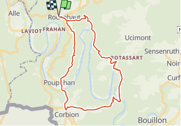

Length
17.5 km

Max alt
387 m

Uphill gradient
638 m
Km-Effort
26 km

Min alt
194 m

Downhill gradient
639 m
Boucle
Yes
Creation date :
2022-02-11 08:56:40.941
Updated on :
2022-02-11 14:32:00.033
5h15
Difficulty : Difficult

FREE GPS app for hiking
 SityTrail
IGN / Geographical institutes
SityTrail Plus
The world is yours!
About
Trail Walking of 17.5 km to be discovered at Wallonia, Luxembourg, Bouillon. This trail is proposed by guyernage25.
Description
Ballade avec de jolis points de vue
Photos


Positioning
Country:
Belgium
Region :
Wallonia
Department/Province :
Luxembourg
Municipality :
Bouillon
Location:
Unknown
Start:(Dec)
Start:(UTM)
644052 ; 5522886 (31U) N.
Comments
Superbe balade avec de très beaux panoramas, et avec une belle alternance de passages dans les bois, le long de l eau, et sur les crêtes.