Trail Walking Taillades - Mas Honorat Gorge de Badarel  - Photo

Mas Honorat Gorge de Badarel

 denel
denel

User

© OpenStreetMap contributors
Length
Length
5.3 km
Max alt
Max alt
354 m
Uphill gradient
Uphill gradient
286 m
Km-Effort
Km-Effort  
9.2 km
Min alt
Min alt
118 m
Downhill gradient
Downhill gradient
288 m
Boucle
Boucle
Yes
Creation date :
2022-02-11 11:29:40.876
Updated on :
2022-03-04 19:25:23.268

(2 Reviews)

Walking
Walking
2h15
Difficulty : Medium

Scan this QR Code to open this trail in the SityTrail application

FREE GPS app for hiking

Logo SityTrail SityTrail

IGN / Geographical institutes

Download SityTrail from the App Store Download SityTrail from Google Play

Logo SityTrail SityTrail Plus

The world is yours!

Download SityTrail from the App Store Download SityTrail from Google Play Download SityTrail on Huawei AppGallery

About

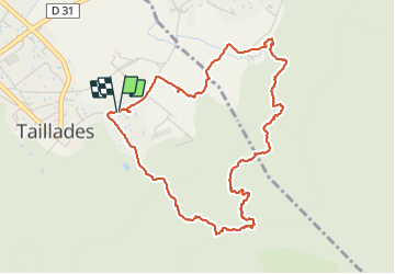
Trail Walking of 5.3 km to be discovered at Provence-Alpes-Côte d'Azur, Vaucluse, Taillades. This trail is proposed by denel.

Description

Rando assez facile avec quand même un passage d'échelle qui peut poser problème avec un animal

On passe par la Gorge de Badarel et retour par le sommet de Castelas  et la vire en dessous du Rocher de Baude

Elevation profile

Positioning

Country:
France
Region :
Provence-Alpes-Côte d'Azur
Department/Province :
Vaucluse
Municipality :
Taillades
Location:
Unknown
Start:(UTM)
668677 ; 4855696 (31T) N.

Comments

Please log in to post a review or rate the element


très beau, attention de bien suivre le tracé en deuxième partie


Close
My subscriptions