![](/images/other/stat-length.png)
![Trail On foot Bobenthal - Hasenkopf-Runde - Photo](https://media.geolcdn.com/t/1900/400/ext.pjpeg?maxdim=2&url=https%3A%2F%2Fmedia.geolcdn.com%2Ff%2Fd8f83b19-46fe-4f0b-af1d-c304a05750ef.jpeg)
Hasenkopf-Runde
SityTrail - itinéraires balisés pédestres
Tous les sentiers balisés d’Europe PRO
![Length](/images/other/stat-length.png)
Length
7.9 km
![Max alt](https://static1.geolcdn.com/siteimages/upload/files/1508320355ic_sort_altitude_max_24dp.png)
Max alt
390 m
![Uphill gradient](https://static1.geolcdn.com/siteimages/upload/files/1508320355ic_sort_den_pos_24dp.png)
Uphill gradient
239 m
![Km-Effort](/images/other/stat-length.png)
Km-Effort
10.9 km
![Min alt](https://static1.geolcdn.com/siteimages/upload/files/1508320355ic_sort_altitude_min_24dp.png)
Min alt
180 m
![Downhill gradient](https://static1.geolcdn.com/siteimages/upload/files/1508320355ic_sort_den_neg_24dp.png)
Downhill gradient
172 m
![Boucle](https://static1.geolcdn.com/siteimages/upload/files/16400158638029165_repeat_loop_refresh_sync_direction_icon.png)
Boucle
No
Signpost
Creation date :
2022-02-11 17:22:17.828
Updated on :
2022-02-11 17:22:17.828
![On foot](https://static1.geolcdn.com/sitytour/trail-icons/100.png)
2h28
Difficulty : Easy
![Scan this QR Code to open this trail in the SityTrail application](https://capi.geolives.com/qq0zvz2zws4bq2lad0pu/sitytour/trails/3097802/qr.png?size=200)
FREE GPS app for hiking
About
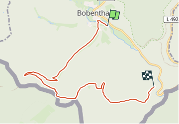
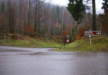
Trail On foot of 7.9 km to be discovered at Rhineland-Palatinate, Südwestpfalz, Bobenthal. This trail is proposed by SityTrail - itinéraires balisés pédestres.
Description
Trail created by Tourist Information Dahner Felsenland.
Symbol: Stilisierter weißer Hase auf blauem Grund mit weißer Unterschrift "Hasenkopf-Runde"
Positioning
Country:
Germany
Region :
Rhineland-Palatinate
Department/Province :
Südwestpfalz
Municipality :
Bobenthal
Location:
Unknown
Start:(Dec)
Start:(UTM)
416782 ; 5434836 (32U) N.
Comments
Trails nearby
![Trail Horseback riding Wingen - 2018-04-07 CRTE Alsace Loewenstein Hohenbourg Fleckenstein - Photo](https://media.geolcdn.com/t/375/260/ext.jpg?maxdim=2&url=https%3A%2F%2Fmedia.geolcdn.com%2Ff%2F70102c74-cde7-4712-ad3f-8ece0b83e7cb.jpg)
![Horseback riding Horseback riding](https://static1.geolcdn.com/sitytour/trail-icons/301.png)
2018-04-07 CRTE Alsace Loewenstein Hohenbourg Fleckenstein
Horseback riding
Medium
(1)
Wingen,
Grand Est,
Bas-Rhin,
France
![](/images/other/stat-length.png)
18.4 km | 26 km-effort
3h 8min
![](https://static1.geolcdn.com/siteimages/upload/files/16400158638029165_repeat_loop_refresh_sync_direction_icon.png)
Yes
![Trail On foot Wingen - Croix rouge - Photo](https://media.geolcdn.com/t/375/260/ext.jpg?maxdim=2&url=https%3A%2F%2Fmedia.geolcdn.com%2Ff%2F59ca20a7-ed62-4c6a-9fd9-47494a5cdd7a.jpeg)
![On foot On foot](https://static1.geolcdn.com/sitytour/trail-icons/100.png)
![Trail On foot Wingen - Anneau rouge - Photo](https://media.geolcdn.com/t/375/260/ext.jpg?maxdim=2&url=https%3A%2F%2Fmedia.geolcdn.com%2Ff%2F06df198a-1199-44ec-a8d9-2d9a150b410c.jpeg)
![On foot On foot](https://static1.geolcdn.com/sitytour/trail-icons/100.png)
![Trail On foot Wissembourg - Rotes Kreuz - Photo](https://media.geolcdn.com/t/375/260/ext.jpg?maxdim=2&url=https%3A%2F%2Fmedia.geolcdn.com%2Ff%2F68ad6046-667d-4bda-b0a1-354cff9d940f.jpeg)
![On foot On foot](https://static1.geolcdn.com/sitytour/trail-icons/100.png)
Rotes Kreuz
On foot
Easy
Wissembourg,
Grand Est,
Bas-Rhin,
France
![](/images/other/stat-length.png)
6.5 km | 9.6 km-effort
2h 11min
![](https://static1.geolcdn.com/siteimages/upload/files/16400158638029165_repeat_loop_refresh_sync_direction_icon.png)
No
![Trail On foot Bobenthal - Hirzeck-Gipfel-Steig - Photo](https://media.geolcdn.com/t/375/260/ext.jpg?maxdim=2&url=https%3A%2F%2Fmedia.geolcdn.com%2Ff%2Ffff086e2-3060-4491-a9c2-5e848399b322.jpeg)
![On foot On foot](https://static1.geolcdn.com/sitytour/trail-icons/100.png)
Hirzeck-Gipfel-Steig
On foot
Easy
Bobenthal,
Rhineland-Palatinate,
Südwestpfalz,
Germany
![](/images/other/stat-length.png)
14.1 km | 19.3 km-effort
4h 22min
![](https://static1.geolcdn.com/siteimages/upload/files/16400158638029165_repeat_loop_refresh_sync_direction_icon.png)
Yes
![Trail On foot Nothweiler - Grenzgängerweg / Le sentier à saute frontier - Photo](https://media.geolcdn.com/t/375/260/ext.jpg?maxdim=2&url=https%3A%2F%2Fmedia.geolcdn.com%2Ff%2F0ec53861-ac09-45f6-98f4-4da71460fa1b.jpeg)
![On foot On foot](https://static1.geolcdn.com/sitytour/trail-icons/100.png)
Grenzgängerweg / Le sentier à saute frontier
On foot
Easy
Nothweiler,
Rhineland-Palatinate,
Südwestpfalz,
Germany
![](/images/other/stat-length.png)
7.2 km | 10.7 km-effort
2h 26min
![](https://static1.geolcdn.com/siteimages/upload/files/16400158638029165_repeat_loop_refresh_sync_direction_icon.png)
Yes
![Trail On foot Wissembourg - Grenzland Tour Schweigen-Rechtenbach - Photo](https://media.geolcdn.com/t/375/260/ext.jpg?maxdim=2&url=https%3A%2F%2Fmedia.geolcdn.com%2Ff%2Fbd736793-f493-4f0d-8fb5-8a1c3d8aadfb.jpeg)
![On foot On foot](https://static1.geolcdn.com/sitytour/trail-icons/100.png)
Grenzland Tour Schweigen-Rechtenbach
On foot
Easy
Wissembourg,
Grand Est,
Bas-Rhin,
France
![](/images/other/stat-length.png)
11.3 km | 15.5 km-effort
3h 30min
![](https://static1.geolcdn.com/siteimages/upload/files/16400158638029165_repeat_loop_refresh_sync_direction_icon.png)
Yes
![Trail On foot Wingen - Rotes Kreuz Nothweiler - Lembach - Photo](https://media.geolcdn.com/t/375/260/ext.jpg?maxdim=2&url=https%3A%2F%2Fmedia.geolcdn.com%2Ff%2F0ec53861-ac09-45f6-98f4-4da71460fa1b.jpeg)
![On foot On foot](https://static1.geolcdn.com/sitytour/trail-icons/100.png)
Rotes Kreuz Nothweiler - Lembach
On foot
Easy
Wingen,
Grand Est,
Bas-Rhin,
France
![](/images/other/stat-length.png)
6.5 km | 9.1 km-effort
2h 4min
![](https://static1.geolcdn.com/siteimages/upload/files/16400158638029165_repeat_loop_refresh_sync_direction_icon.png)
No
![Trail On foot Wissembourg - Anneau jaune - Photo](https://media.geolcdn.com/t/375/260/ext.jpg?maxdim=2&url=https%3A%2F%2Fmedia.geolcdn.com%2Ff%2F55a6a0a6-0f10-4437-aabb-c766882fbdd8.jpeg)
![On foot On foot](https://static1.geolcdn.com/sitytour/trail-icons/100.png)
Anneau jaune
On foot
Easy
Wissembourg,
Grand Est,
Bas-Rhin,
France
![](/images/other/stat-length.png)
5.4 km | 7.7 km-effort
1h 45min
![](https://static1.geolcdn.com/siteimages/upload/files/16400158638029165_repeat_loop_refresh_sync_direction_icon.png)
Yes