


tacot

Poisel
User
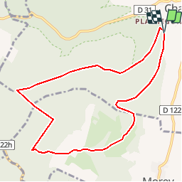

Length
9.2 km

Max alt
477 m

Uphill gradient
165 m
Km-Effort
11.4 km

Min alt
312 m

Downhill gradient
168 m
Boucle
Yes
Creation date :
2014-12-10 00:00:00.0
Updated on :
2014-12-10 00:00:00.0
--
Difficulty : Unknown

FREE GPS app for hiking
 SityTrail
IGN / Geographical institutes
SityTrail Plus
The world is yours!
About
Trail Walking of 9.2 km to be discovered at Bourgogne-Franche-Comté, Côte-d'Or, Gevrey-Chambertin. This trail is proposed by Poisel.
Positioning
Country:
France
Region :
Bourgogne-Franche-Comté
Department/Province :
Côte-d'Or
Municipality :
Gevrey-Chambertin
Location:
Unknown
Start:(Dec)
Start:(UTM)
648657 ; 5231616 (31T) N.
Comments