


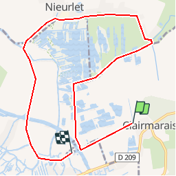
Canoé Clairmarais

lepompi
User

Length
9.3 km

Max alt
5 m

Uphill gradient
31 m
Km-Effort
9.7 km

Min alt
-1 m

Downhill gradient
29 m
Boucle
No
Creation date :
2014-12-10 00:00:00.0
Updated on :
2018-10-13 16:46:04.783
--
Difficulty : Very easy

FREE GPS app for hiking
 SityTrail
IGN / Geographical institutes
SityTrail Plus
The world is yours!
About
Trail Canoe - kayak of 9.3 km to be discovered at Hauts-de-France, Pas-de-Calais, Clairmarais. This trail is proposed by lepompi.
Description
Grand Tour du Romelaere
Location barque sur place ou
canoé personnel
Restauration sur place possible et je vous recommande porcelet grillé !!
Positioning
Country:
France
Region :
Hauts-de-France
Department/Province :
Pas-de-Calais
Municipality :
Clairmarais
Location:
Unknown
Start:(Dec)
Start:(UTM)
450593 ; 5624503 (31U) N.
Comments