![](/images/other/stat-length.png)
![Trail On foot Birresborn - Bertrada Route - Photo](https://media.geolcdn.com/t/1900/400/ext.pjpeg?maxdim=2&url=https%3A%2F%2Fmedia.geolcdn.com%2Ff%2F88c24b6a-7f61-496b-8b0a-2d0fd807ca49.jpeg)
Bertrada Route
SityTrail - itinéraires balisés pédestres
Tous les sentiers balisés d’Europe PRO
![Length](/images/other/stat-length.png)
Length
13.7 km
![Max alt](https://static1.geolcdn.com/siteimages/upload/files/1508320355ic_sort_altitude_max_24dp.png)
Max alt
561 m
![Uphill gradient](https://static1.geolcdn.com/siteimages/upload/files/1508320355ic_sort_den_pos_24dp.png)
Uphill gradient
450 m
![Km-Effort](/images/other/stat-length.png)
Km-Effort
19.6 km
![Min alt](https://static1.geolcdn.com/siteimages/upload/files/1508320355ic_sort_altitude_min_24dp.png)
Min alt
318 m
![Downhill gradient](https://static1.geolcdn.com/siteimages/upload/files/1508320355ic_sort_den_neg_24dp.png)
Downhill gradient
447 m
![Boucle](https://static1.geolcdn.com/siteimages/upload/files/16400158638029165_repeat_loop_refresh_sync_direction_icon.png)
Boucle
Yes
Signpost
Creation date :
2022-02-11 20:07:37.16
Updated on :
2022-02-11 20:07:37.16
![On foot](https://static1.geolcdn.com/sitytour/trail-icons/100.png)
4h27
Difficulty : Easy
![Scan this QR Code to open this trail in the SityTrail application](https://capi.geolives.com/qq0zvz2zws4bq2lad0pu/sitytour/trails/3101448/qr.png?size=200)
FREE GPS app for hiking
About
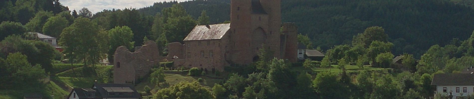
Trail On foot of 13.7 km to be discovered at Rhineland-Palatinate, Landkreis Vulkaneifel, Birresborn. This trail is proposed by SityTrail - itinéraires balisés pédestres.
Description
Trail created by Tourist-Information Gerolsteiner Land.
Symbol: "Rote Turmburg in wwasserstehend oben in schwarzer Schrift: "Bertrada Tour" vor weißem Hintergrund"
Positioning
Country:
Germany
Region :
Rhineland-Palatinate
Department/Province :
Landkreis Vulkaneifel
Municipality :
Birresborn
Location:
Unknown
Start:(Dec)
Start:(UTM)
330402 ; 5560148 (32U) N.
Comments
Trails nearby
![Trail Walking Gerolstein - Duitsland - Buscheich in Eiffel - Photo](https://media.geolcdn.com/t/375/260/ext.jpg?maxdim=2&url=https%3A%2F%2Fstatic1.geolcdn.com%2Fsiteimages%2Fupload%2Ffiles%2F1553511878bg_sport_marche.png)
![Walking Walking](https://static1.geolcdn.com/sitytour/trail-icons/101.png)
Duitsland - Buscheich in Eiffel
Walking
Very easy
Gerolstein,
Rhineland-Palatinate,
Landkreis Vulkaneifel,
Germany
![](/images/other/stat-length.png)
14.7 km | 21 km-effort
Unknown
![](https://static1.geolcdn.com/siteimages/upload/files/16400158638029165_repeat_loop_refresh_sync_direction_icon.png)
Yes
![Trail sport Kopp - Eigelbacher maar (Wolffhotel Kopp - Photo](https://media.geolcdn.com/t/375/260/ext.jpg?maxdim=2&url=https%3A%2F%2Fsecurestorage.geolives.com%2Fsitytour%2Ftrail-bg%2Fdefault.jpg)
Eigelbacher maar (Wolffhotel Kopp
sport
Very easy
Kopp,
Rhineland-Palatinate,
Landkreis Vulkaneifel,
Germany
![](/images/other/stat-length.png)
6.3 km | 8.7 km-effort
Unknown
![](https://static1.geolcdn.com/siteimages/upload/files/16400158638029165_repeat_loop_refresh_sync_direction_icon.png)
No