


Trimbach au val

delm
User
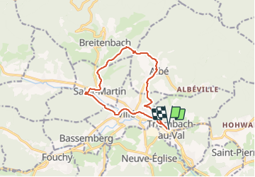

Length
12 km

Max alt
461 m

Uphill gradient
378 m
Km-Effort
17.1 km

Min alt
256 m

Downhill gradient
379 m
Boucle
Yes
Creation date :
2022-02-09 13:18:56.0
Updated on :
2022-02-12 11:48:40.528
70h13
Difficulty : Easy

FREE GPS app for hiking
 SityTrail
IGN / Geographical institutes
SityTrail Plus
The world is yours!
About
Trail Walking of 12 km to be discovered at Grand Est, Bas-Rhin, Triembach-au-Val. This trail is proposed by delm.
Description
Très belle randonnée
Positioning
Country:
France
Region :
Grand Est
Department/Province :
Bas-Rhin
Municipality :
Triembach-au-Val
Location:
Unknown
Start:(Dec)
Start:(UTM)
375788 ; 5355194 (32U) N.
Comments