


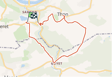
Maizeret Goyet Thon boucle

thomarche
User

Length
7.7 km

Max alt
204 m

Uphill gradient
163 m
Km-Effort
10 km

Min alt
87 m

Downhill gradient
209 m
Boucle
No
Creation date :
2022-02-12 14:51:26.0
Updated on :
2022-02-12 16:50:55.098
1h59
Difficulty : Very easy

FREE GPS app for hiking
 SityTrail
IGN / Geographical institutes
SityTrail Plus
The world is yours!
About
Trail Walking of 7.7 km to be discovered at Wallonia, Namur, Andenne. This trail is proposed by thomarche.
Description
Belle boucle facile
Positioning
Country:
Belgium
Region :
Wallonia
Department/Province :
Namur
Municipality :
Andenne
Location:
Thon
Start:(Dec)
Start:(UTM)
641532 ; 5591820 (31U) N.
Comments