


Vienne en val Sud_Est

lemuid
User
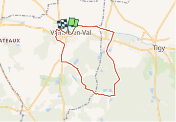

Length
13.1 km

Max alt
150 m

Uphill gradient
110 m
Km-Effort
14.6 km

Min alt
99 m

Downhill gradient
110 m
Boucle
Yes
Creation date :
2022-02-13 07:24:47.94
Updated on :
2022-02-13 13:26:03.631
2h30
Difficulty : Very easy

FREE GPS app for hiking
 SityTrail
IGN / Geographical institutes
SityTrail Plus
The world is yours!
About
Trail Walking of 13.1 km to be discovered at Centre-Loire Valley, Loiret, Vienne-en-Val. This trail is proposed by lemuid.
Description
Randonnée de la St Valentin 1020 participants
très belle organisation, merci aux 80 bénèvoles
Positioning
Country:
France
Region :
Centre-Loire Valley
Department/Province :
Loiret
Municipality :
Vienne-en-Val
Location:
Unknown
Start:(Dec)
Start:(UTM)
435291 ; 5294624 (31T) N.
Comments