Ijean et tour au dessus de Martignat

cailloux54
User
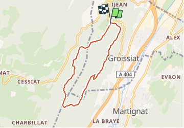

Length
6.5 km

Max alt
819 m

Uphill gradient
228 m
Km-Effort
9.6 km

Min alt
591 m

Downhill gradient
243 m
Boucle
Yes
Creation date :
2022-02-13 08:24:55.509
Updated on :
2022-02-13 12:40:00.679
2h15
Difficulty : Easy

FREE GPS app for hiking
 SityTrail
IGN / Geographical institutes
SityTrail Plus
The world is yours!
About
Trail Walking of 6.5 km to be discovered at Auvergne-Rhône-Alpes, Ain, Groissiat. This trail is proposed by cailloux54.
Positioning
Country:
France
Region :
Auvergne-Rhône-Alpes
Department/Province :
Ain
Municipality :
Groissiat
Location:
Unknown
Start:(Dec)
Start:(UTM)
700779 ; 5122866 (31T) N.
Comments