


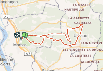
Mornas

raygautier
User

Length
20 km

Max alt
186 m

Uphill gradient
457 m
Km-Effort
26 km

Min alt
51 m

Downhill gradient
456 m
Boucle
Yes
Creation date :
2022-02-13 08:01:40.0
Updated on :
2022-02-13 18:11:10.276
6h42
Difficulty : Unknown

FREE GPS app for hiking
 SityTrail
IGN / Geographical institutes
SityTrail Plus
The world is yours!
About
Trail Walking of 20 km to be discovered at Provence-Alpes-Côte d'Azur, Vaucluse, Mornas. This trail is proposed by raygautier.
Positioning
Country:
France
Region :
Provence-Alpes-Côte d'Azur
Department/Province :
Vaucluse
Municipality :
Mornas
Location:
Unknown
Start:(Dec)
Start:(UTM)
638243 ; 4895999 (31T) N.
Comments