


Charnay les Macon/Salornay

janussity
User
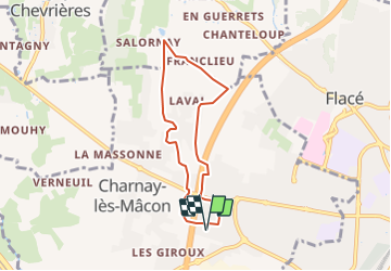

Length
6.4 km

Max alt
301 m

Uphill gradient
114 m
Km-Effort
7.9 km

Min alt
215 m

Downhill gradient
113 m
Boucle
Yes
Creation date :
2022-02-14 09:22:30.023
Updated on :
2022-02-14 09:24:51.32
1h48
Difficulty : Medium

FREE GPS app for hiking
 SityTrail
IGN / Geographical institutes
SityTrail Plus
The world is yours!
About
Trail Walking of 6.4 km to be discovered at Bourgogne-Franche-Comté, Saône-et-Loire, Charnay-lès-Mâcon. This trail is proposed by janussity.
Description
Facile
Positioning
Country:
France
Region :
Bourgogne-Franche-Comté
Department/Province :
Saône-et-Loire
Municipality :
Charnay-lès-Mâcon
Location:
Unknown
Start:(Dec)
Start:(UTM)
638335 ; 5129625 (31T) N.
Comments