


Mon parcours

c.chehere
User
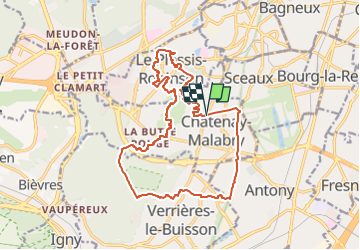

Length
17.5 km

Max alt
181 m

Uphill gradient
272 m
Km-Effort
21 km

Min alt
80 m

Downhill gradient
275 m
Boucle
Yes
Creation date :
2022-02-14 11:36:23.552
Updated on :
2022-06-07 05:32:44.955
4h49
Difficulty : Medium

FREE GPS app for hiking
 SityTrail
IGN / Geographical institutes
SityTrail Plus
The world is yours!
About
Trail Walking of 17.5 km to be discovered at Ile-de-France, Hauts-de-Seine, Châtenay-Malabry. This trail is proposed by c.chehere.
Description
Bus 294 arrêt "Jean Jaurès"
Positioning
Country:
France
Region :
Ile-de-France
Department/Province :
Hauts-de-Seine
Municipality :
Châtenay-Malabry
Location:
Unknown
Start:(Dec)
Start:(UTM)
446662 ; 5402174 (31U) N.
Comments