


Givry Balade Saint Martin page101

grasgilbert
User
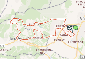

Length
11.8 km

Max alt
417 m

Uphill gradient
337 m
Km-Effort
16.3 km

Min alt
224 m

Downhill gradient
338 m
Boucle
Yes
Creation date :
2022-02-14 13:45:12.655
Updated on :
2022-02-14 13:50:47.247
3h39
Difficulty : Difficult

FREE GPS app for hiking
 SityTrail
IGN / Geographical institutes
SityTrail Plus
The world is yours!
About
Trail Walking of 11.8 km to be discovered at Bourgogne-Franche-Comté, Saône-et-Loire, Givry. This trail is proposed by grasgilbert.
Positioning
Country:
France
Region :
Bourgogne-Franche-Comté
Department/Province :
Saône-et-Loire
Municipality :
Givry
Location:
Unknown
Start:(Dec)
Start:(UTM)
632413 ; 5181703 (31T) N.
Comments
très bien