Trail On foot Berg en Dal - N-70 Natuurwandelroute - Photo

N-70 Natuurwandelroute

Tous les sentiers balisés d’Europe GUIDE+

© OpenStreetMap contributors
Length
Length
14 km
Max alt
Max alt
96 m
Uphill gradient
Uphill gradient
351 m
Km-Effort
Km-Effort  
18.7 km
Min alt
Min alt
14 m
Downhill gradient
Downhill gradient
352 m
Boucle
Boucle
Yes
Signpost
Signpost
Creation date :
2022-02-14 14:25:27.723
Updated on :
2022-02-14 14:25:27.723

(0 Reviews)

On foot
On foot
4h15
Difficulty : Easy

Scan this QR Code to open this trail in the SityTrail application

FREE GPS app for hiking

Logo SityTrail SityTrail

IGN / Geographical institutes

Download SityTrail from the App Store Download SityTrail from Google Play

Logo SityTrail SityTrail Plus

The world is yours!

Download SityTrail from the App Store Download SityTrail from Google Play Download SityTrail on Huawei AppGallery

About

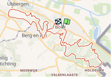
Trail On foot of 14 km to be discovered at Gelderland, Unknown, Berg en Dal. This trail is proposed by SityTrail - itinéraires balisés pédestres.

Description

Trail created by Natuurbescherming / Regionaal Bureau voor Toerisme Arnhem Nijmegen.

Symbol: green

Elevation profile

Photos

Positioning

Country:
Netherlands
Region :
Gelderland
Department/Province :
Unknown
Municipality :
Berg en Dal
Location:
Unknown
Start:(UTM)
701617 ; 5745991 (31U) N.


Close
My subscriptions