


Schapenparkroute

SityTrail - itinéraires balisés pédestres
Tous les sentiers balisés d’Europe GUIDE+
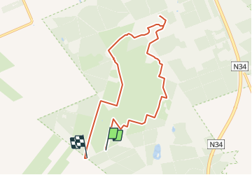

Length
7.5 km

Max alt
37 m

Uphill gradient
48 m
Km-Effort
8.1 km

Min alt
16 m

Downhill gradient
48 m
Boucle
No

Signpost
Creation date :
2022-02-14 14:30:40.129
Updated on :
2022-02-14 14:30:40.129
1h50
Difficulty : Easy

FREE GPS app for hiking
 SityTrail
IGN / Geographical institutes
SityTrail Plus
The world is yours!
About
Trail On foot of 7.5 km to be discovered at Drenthe, Unknown, Borger-Odoorn. This trail is proposed by SityTrail - itinéraires balisés pédestres.
Photos


Positioning
Country:
Netherlands
Region :
Drenthe
Department/Province :
Unknown
Municipality :
Borger-Odoorn
Location:
Unknown
Start:(Dec)
Start:(UTM)
352055 ; 5858266 (32U) N.
Comments