


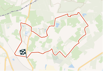
Galgengoorroute

SityTrail - itinéraires balisés pédestres
Tous les sentiers balisés d’Europe GUIDE+


2h29
Difficulty : Easy

FREE GPS app for hiking
 SityTrail
IGN / Geographical institutes
SityTrail Plus
The world is yours!
About
Trail On foot of 10 km to be discovered at Gelderland, Unknown, Bronckhorst. This trail is proposed by SityTrail - itinéraires balisés pédestres.
Description
Trail created by Recreatieschap Achterhoek Liemers.
Website: http://www.recreatieschap.nl/startpunten/top_vorden.aspx
Photos


Positioning
Comments