Trail On foot Arnhem - NS-wandeling Warnsborn - Photo

NS-wandeling Warnsborn

Tous les sentiers balisés d’Europe GUIDE+

© OpenStreetMap contributors
Length
Length
19.7 km
Max alt
Max alt
82 m
Uphill gradient
Uphill gradient
226 m
Km-Effort
Km-Effort  
23 km
Min alt
Min alt
18 m
Downhill gradient
Downhill gradient
229 m
Boucle
Boucle
No
Signpost
Signpost
Creation date :
2022-02-14 15:03:18.263
Updated on :
2022-02-14 15:03:18.263

(0 Reviews)

On foot
On foot
5h09
Difficulty : Medium

Scan this QR Code to open this trail in the SityTrail application

FREE GPS app for hiking

Logo SityTrail SityTrail

IGN / Geographical institutes

Download SityTrail from the App Store Download SityTrail from Google Play

Logo SityTrail SityTrail Plus

The world is yours!

Download SityTrail from the App Store Download SityTrail from Google Play Download SityTrail on Huawei AppGallery

About

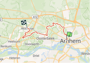
Trail On foot of 19.7 km to be discovered at Gelderland, Unknown, Arnhem. This trail is proposed by SityTrail - itinéraires balisés pédestres.

Description

Voor wie houdt van een boswandeling met de nodige afwisseling is de NS-wandeling Warnsborn een goede optie.

Website: https://www.ns.nl/dagje-uit/wandelen/warnsborn.html

Elevation profile

Photos

Positioning

Country:
Netherlands
Region :
Gelderland
Department/Province :
Unknown
Municipality :
Arnhem
Location:
Unknown
Start:(UTM)
699066 ; 5763410 (31U) N.


Close
My subscriptions