Trail On foot Patones - Ruta 1: Subida al Cancho de la Cabeza por el Arroyo de Patones - Photo

Ruta 1: Subida al Cancho de la Cabeza por el Arroyo de Patones

Tous les sentiers balisés d’Europe PRO

© OpenStreetMap contributors
Length
Length
12.4 km
Max alt
Max alt
1250 m
Uphill gradient
Uphill gradient
547 m
Km-Effort
Km-Effort  
19.6 km
Min alt
Min alt
722 m
Downhill gradient
Downhill gradient
547 m
Boucle
Boucle
Yes
Signpost
Signpost
Creation date :
2022-02-14 15:58:12.527
Updated on :
2022-02-14 15:58:12.527

(0 Reviews)

On foot
On foot
4h27
Difficulty : Easy

Scan this QR Code to open this trail in the SityTrail application

FREE GPS app for hiking

Logo SityTrail SityTrail

IGN / Geographical institutes

Download SityTrail from the App Store Download SityTrail from Google Play

Logo SityTrail SityTrail World

The world is yours!

Download SityTrail from the App Store Download SityTrail from Google Play Download SityTrail on Huawei AppGallery

About

Trail On foot of 12.4 km to be discovered at Community of Madrid, Unknown, Patones. This trail is proposed by SityTrail - itinéraires balisés pédestres.

Description

En la subida al Cancho de la Cabeza descubre una impresionante vista panorámica. Ruta circular de cuatro horas de duración con vistas al embalse.

Website: http://turismo.patones.net/actividades/rutas/cumbre-del-cancho-de-la-cabeza/

Photos

Positioning

Country:
Spain
Region :
Community of Madrid
Department/Province :
Unknown
Municipality :
Patones
Location:
Unknown
Start:(UTM)
458966 ; 4523089 (30T) N.

Trails nearby

Trail On foot Patones - Ruta 2: Vuelta al Cabezo - Photo
On foot
PRO

On foot

Easy
Patones, Community of Madrid, Unknown, Spain
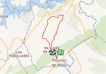
6.6 km | 10.5 km-effort
2h 22min
Yes
Trail On foot Uceda - Senda 2: Remontando el Lozoya hasta la Presa de la Parra - Photo
On foot
PRO

On foot

Easy
Uceda, Castile-La Mancha, Guadalajara, Spain
7.7 km | 9.3 km-effort
2h 6min
No


Close
My subscriptions