


SE_Agnel

lucienp
User

Length
63 km

Max alt
2743 m

Uphill gradient
2589 m
Km-Effort
92 km

Min alt
859 m

Downhill gradient
779 m
Boucle
No
Creation date :
2014-12-10 00:00:00.0
Updated on :
2014-12-10 00:00:00.0
5h16
Difficulty : Medium

FREE GPS app for hiking
 SityTrail
IGN / Geographical institutes
SityTrail Plus
The world is yours!
About
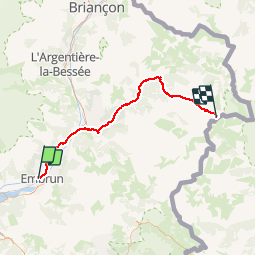
Trail Cycle of 63 km to be discovered at Provence-Alpes-Côte d'Azur, Hautes-Alpes, Embrun. This trail is proposed by lucienp.
Description
Col d'Agnel
Positioning
Country:
France
Region :
Provence-Alpes-Côte d'Azur
Department/Province :
Hautes-Alpes
Municipality :
Embrun
Location:
Unknown
Start:(Dec)
Start:(UTM)
300481 ; 4937693 (32T) N.
Comments