


Chemin Royal

SityTrail - itinéraires balisés pédestres
Tous les sentiers balisés d’Europe GUIDE+
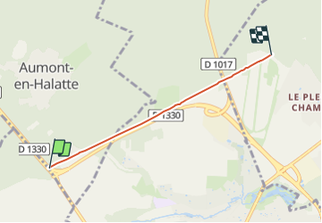

Length
3.5 km

Max alt
96 m

Uphill gradient
44 m
Km-Effort
4 km

Min alt
73 m

Downhill gradient
29 m
Boucle
No

Signpost
Creation date :
2022-02-15 06:05:01.939
Updated on :
2022-03-02 14:39:29.274
54m
Difficulty : Easy

FREE GPS app for hiking
 SityTrail
IGN / Geographical institutes
SityTrail Plus
The world is yours!
About
Trail On foot of 3.5 km to be discovered at Hauts-de-France, Oise, Aumont-en-Halatte. This trail is proposed by SityTrail - itinéraires balisés pédestres.
Photos


Positioning
Country:
France
Region :
Hauts-de-France
Department/Province :
Oise
Municipality :
Aumont-en-Halatte
Location:
Unknown
Start:(Dec)
Start:(UTM)
467588 ; 5451744 (31U) N.
Comments