


D'Igny à Bagneux par Fresnes

c.chehere
User
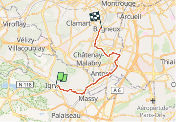

Length
18.1 km

Max alt
107 m

Uphill gradient
180 m
Km-Effort
20 km

Min alt
44 m

Downhill gradient
154 m
Boucle
No
Creation date :
2022-02-15 06:58:55.203
Updated on :
2022-10-15 07:06:27.779
4h28
Difficulty : Medium

FREE GPS app for hiking
 SityTrail
IGN / Geographical institutes
SityTrail Plus
The world is yours!
About
Trail Walking of 18.1 km to be discovered at Ile-de-France, Essonne, Igny. This trail is proposed by c.chehere.
Photos


Positioning
Country:
France
Region :
Ile-de-France
Department/Province :
Essonne
Municipality :
Igny
Location:
Unknown
Start:(Dec)
Start:(UTM)
443481 ; 5398849 (31U) N.
Comments