Trail On foot Chiuro - Valtellina wine trail half trail 21km - Photo

Valtellina wine trail half trail 21km

Tous les sentiers balisés d’Europe PRO

© OpenStreetMap contributors
Length
Length
11.8 km
Max alt
Max alt
717 m
Uphill gradient
Uphill gradient
565 m
Km-Effort
Km-Effort  
18.9 km
Min alt
Min alt
353 m
Downhill gradient
Downhill gradient
411 m
Boucle
Boucle
No
Signpost
Signpost
Creation date :
2022-02-15 13:24:58.638
Updated on :
2022-03-01 11:55:26.629

(0 Reviews)

On foot
On foot
4h17
Difficulty : Easy

Scan this QR Code to open this trail in the SityTrail application

FREE GPS app for hiking

Logo SityTrail SityTrail

IGN / Geographical institutes

Download SityTrail from the App Store Download SityTrail from Google Play

Logo SityTrail SityTrail World

The world is yours!

Download SityTrail from the App Store Download SityTrail from Google Play Download SityTrail on Huawei AppGallery

About

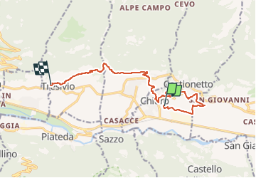
Trail On foot of 11.8 km to be discovered at Lombardy, Sondrio, Chiuro. This trail is proposed by SityTrail - itinéraires balisés pédestres.

Description

Valtellina Wine Trail, una gara spettacolare fra i terrazzamenti dei vigneti della Valtellina. Non una semplice gara di trail-running, ma una vera e propria esperienza ed immersione nella storia, nel territorio e nella cultura delle eccellenze valtellinesi, la simbiosi unica tra sport e patrimonio enogastronomico.

Website: http://www.valtellinawinetrail.com

Photos

Positioning

Country:
Italy
Region :
Lombardy
Department/Province :
Sondrio
Municipality :
Chiuro
Location:
Unknown
Start:(UTM)
576747 ; 5113316 (32T) N.

Trails nearby

Trail On foot Teglio - (SI D29N) Prato Valentino - Madonna di Tirano - Photo
On foot
PRO

On foot

Difficult
Teglio, Lombardy, Sondrio, Italy
19.5 km | 35 km-effort
8h 0min
No
Trail On foot Teglio - (Alta via Val Fontana) Alpe Campascio - Prato Valentino - Photo
On foot
PRO

On foot

Very difficult
Teglio, Lombardy, Sondrio, Italy
28 km | 56 km-effort
12h 37min
No


Close
My subscriptions