


Louette-St-Denis 17 février 22

pierlan
User
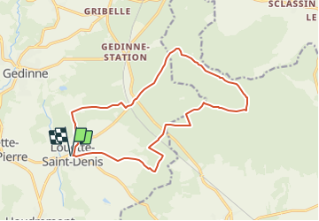

Length
15.4 km

Max alt
439 m

Uphill gradient
314 m
Km-Effort
19.6 km

Min alt
347 m

Downhill gradient
314 m
Boucle
Yes
Creation date :
2020-12-06 16:47:19.52
Updated on :
2022-02-16 13:12:30.097
--
Difficulty : Very easy

FREE GPS app for hiking
 SityTrail
IGN / Geographical institutes
SityTrail Plus
The world is yours!
About
Trail Trail of 15.4 km to be discovered at Wallonia, Namur, Gedinne. This trail is proposed by pierlan.
Positioning
Country:
Belgium
Region :
Wallonia
Department/Province :
Namur
Municipality :
Gedinne
Location:
Unknown
Start:(Dec)
Start:(UTM)
640353 ; 5535847 (31U) N.
Comments