


Hahnenberg

PhilippeC54
User
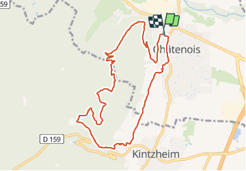

Length
10 km

Max alt
525 m

Uphill gradient
361 m
Km-Effort
14.8 km

Min alt
187 m

Downhill gradient
362 m
Boucle
Yes
Creation date :
2022-02-16 13:51:04.805
Updated on :
2022-02-16 16:55:04.898
2h45
Difficulty : Easy

FREE GPS app for hiking
 SityTrail
IGN / Geographical institutes
SityTrail Plus
The world is yours!
About
Trail Walking of 10 km to be discovered at Grand Est, Bas-Rhin, Châtenois. This trail is proposed by PhilippeC54.
Positioning
Country:
France
Region :
Grand Est
Department/Province :
Bas-Rhin
Municipality :
Châtenois
Location:
Unknown
Start:(Dec)
Start:(UTM)
381129 ; 5348097 (32U) N.
Comments